A Global Positioning Satellite (GPS) receiver designed to attach to the hotshoe of digital SLRs is predicted to help trigger a ?geotagging? revolution.
Though not due to be officially launched until the Photokina trade show in September, a working prototype version of the device has been shown to Amateur Photographer magazine (AP).
Geotagging allows photographers to automatically assign GPS data to their pictures. Its protagonists expect such technology to win mass market appeal ? making life easier for photographers by helping them manage their collection and quickly search their image database, based on the location data embedded in the image file.
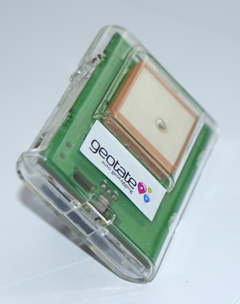
Geotate?s ?100 device, called Kato, uses its own built-in memory (to store GPS data) and a rechargeable battery.
Geotate hopes that such ?instant GPS camera technology? will trigger an explosion in location tagging of images.
?We think [automatic geotagging] will become a standard feature on cameras,? said Paul Gough, Geotate?s senior director for product development.
Geotate draws on research predicting that the GPS camera sector will increase five-fold by 2011.
Though GPS accessory units for cameras are nothing new, Geotate claims its ?USB GPS logger capture device? offers key advantages over other GPS units in that it frees up picture taking and uses less power.
This, explains the company, is because the processing of GPS information takes place after the GPS data is transferred to computer, rather than at the time the shot is taken. In other words, the user doesn?t have to wait for the GPS to process information obtained from an orbiting satellite while out and about taking shots.
Gough explained that the new device captures a ?sample? GPS signal in under 200msec. This signal data is stored and a timestamp is written into the capture record.
Unlike Sony?s portable Cyber-shot GPS-CS1 unit, for example, it does not continually page GPS satellites to establish the photographer?s position. It records GPS data only when a picture is taken.
?In comparison, a traditional GPS device will take a few seconds to find the satellite signals, around 30sec to download satellite orbit information and a few seconds to calculate the user?s position,? claims Geotate.
And the user does not need to manually input location data ? in contrast to software-only systems operated by Flickr and Microsoft, for example, which do not require a GPS unit but require the user to link their downloaded photos with data plucked from an internet-based map.
When the photographer wants to ?geotag? their images using the Kato, they transfer the GPS data to computer by attaching the unit via a USB cable. The images are downloaded from the camera, or transferred from the camera?s memory card, in the traditional way.
Once the GPS signal time is matched with the time that the image was shot, software processes the GPS data and satellite information (downloaded from the internet) to ascertain the photographer?s location at the time of the shot. There are 31 such satellites orbiting the earth.
The system then ?geotags? the information, storing it in the image?s EXIF data and enabling the location to be displayed on an internet-based map system such as Google Earth.
Geotate claims the device can last for 90 days without recharging.
The system demonstrated to AP worked on JPEG format images. But Geotate plans to develop a version also compatible with raw images, ready for the UK launch this autumn.
A ?white paper? on the technology, launched earlier this year names ?Samsung? as the third party working with Geotate on the device.
In Geotate?s meeting with AP, a working pre-production version of the device was mounted on a Nikon D40 (pictured below). Gough told us that, so far, it has also been trialed on Canon, Panasonic, Pentax and Sony DSLRs (though the latter requires an adapter).
And its maker has confirmed it will include a connector for attaching a flash unit if needed. The early model shown to AP did not have this facility. A greater memory capacity model is also expected than the 128MB version shown.
The firm plans to launch a smaller version of the device suitable for compact cameras sometime next year.
The Geotate device is accurate down to 12m provided there is a ?good view of the sky?, explained Gough, adding that the proximity of high-rise buildings can affect the GPS signal.
In theory, once an image?s location data in established, other information, appropriate to the picture position, could also be added to the image file, via the internet.
?Tagging geographic data is just the start,? adds Geotate. ?Imagine being able to layer on other data like meteorological conditions. So, for example, it would be possible to search for photos that match the description ?sunny London in winter?.
Initially, Geotate expects the accessory to appeal to the professional market.
It hopes it will be snapped up by photographers who want to create a ?travel diary?.
? For a full report see this week?s issue of Amateur Photographer, in shops now
Pictures: A working prototype of the ‘Kato’, demonstrated on the Nikon D40 DSLR